Ryn Arnold's Photography Blog

Latest

Summer is for Hiking Part 3: Yosemite National Park, Mono Pass Trail to Spillover/ Spillway Lake, July 26, 2014

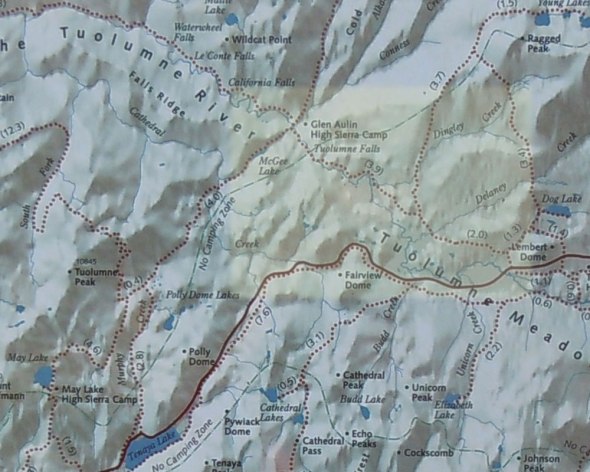
Trail Map and info for Mono Pass Trailhead – highlighted in yellow below. This map can be enlarged by clicking on it.

I highly recommend this hike – on the day I traveled, the temperatures were in the upper 70s and low 80s. Compare this to the Valley floor topping at 99 plus the smoke from the many fires – this was an outstanding meander into the wilderness. The hike is a steady upward climb – but nowhere extremely steep. The elevation gain is about 1000 feet over about approximately 4 miles.

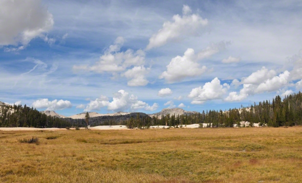
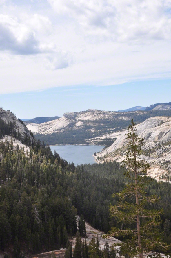
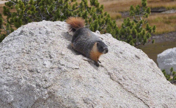
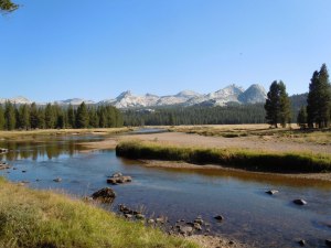
Multiple meadows – one meadow after another currently full of wildflowers named appropriately Dana Meadows.This time I went to Spillover/Spillway Lake – next time I plan to go straight up to Mono Pass as there are a few additional lakes  near the Pass (small ones), one named Summit Lake  and just a bit further The Upper and Lower Sardine Lakes. It is also said you can view Mono Lake from up there as well. You can also take a trail /loop over to Mono Pass trail from Spillway Lake.

DSC_0101
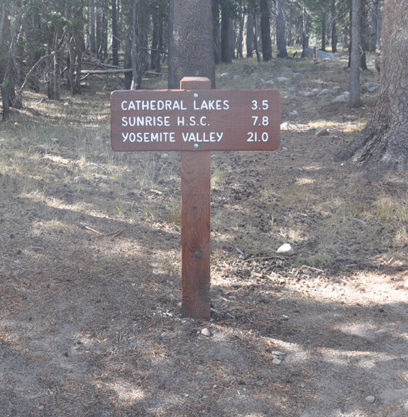
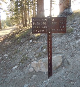
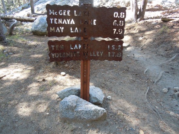
Below is the sign for Spillover Lake at around 2.3 miles. Go to the right for Spillover/Spillway Lake, go to the left for Mono Pass.  spillway lake signThe trail to the lake was still a bit marshy on spots – but most was dried out making late July a good time to do this hike. There are meadows and wildflowers everywhere.

DSC_0174DSC_0185DSC_0173
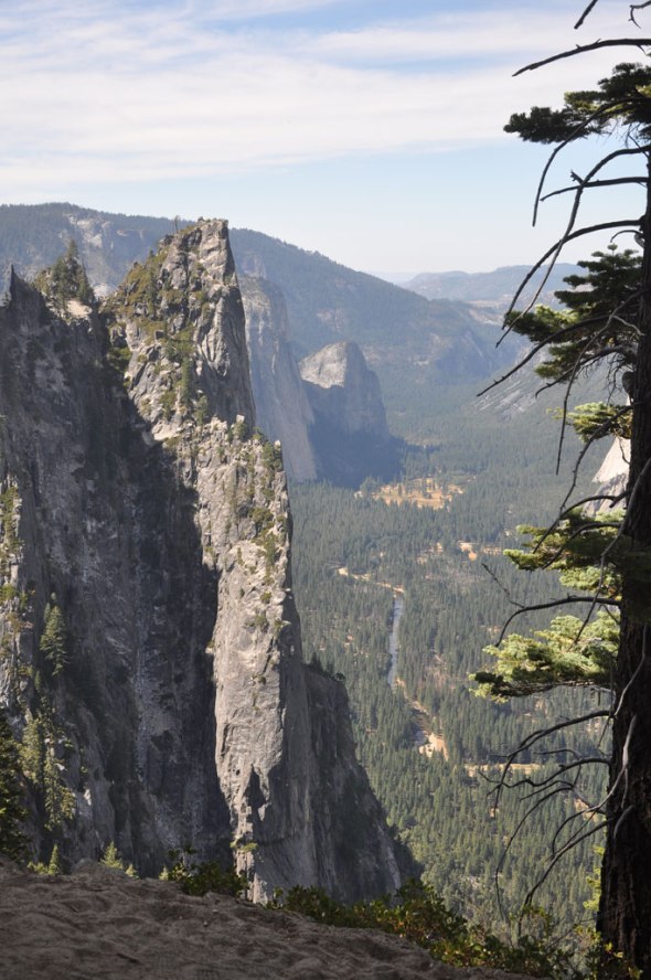
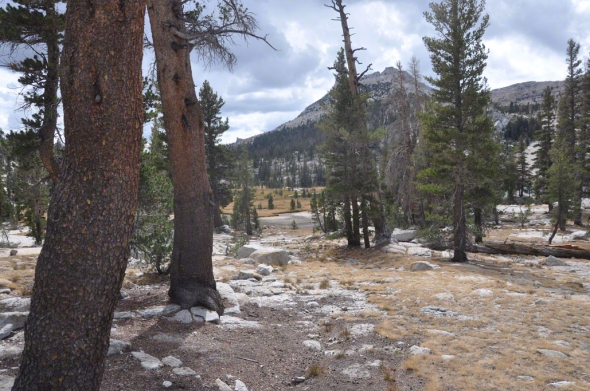
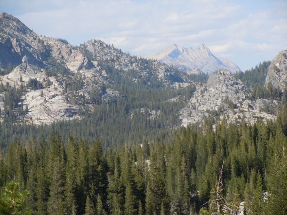
The trail often runs alongside Parker Pass Creek with Kuna Crest, Mammoth Peak and Mount Lewis which are above 12,000 feet tall.

DSC_0138DSC_0118DSC_0119
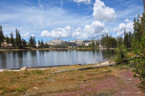
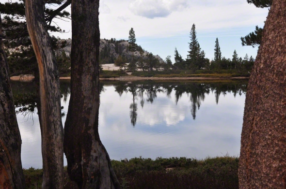
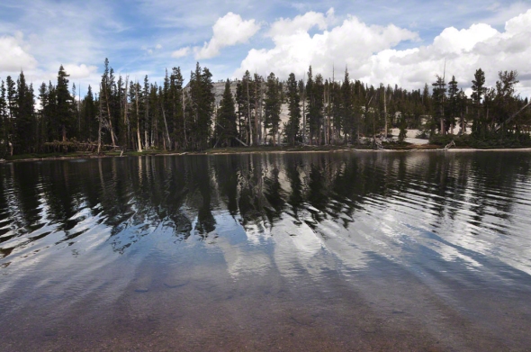
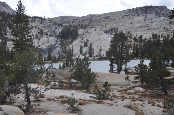
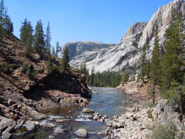
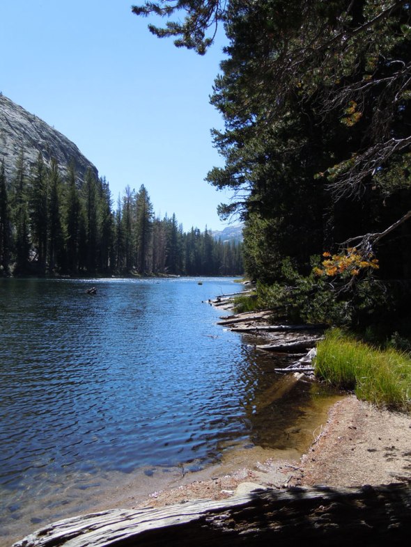
From the lake – or before the lake, you can take a trail over to the Mono Pass trail. The lake itself is quite beautiful and in an amazing secluded setting.

DSC_0122DSC_0127DSC_0130
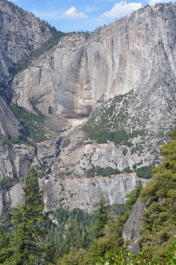
Snow still lies along the mountain tops facing East and Southeast  – this is the end of July so am not sure it ever melts.

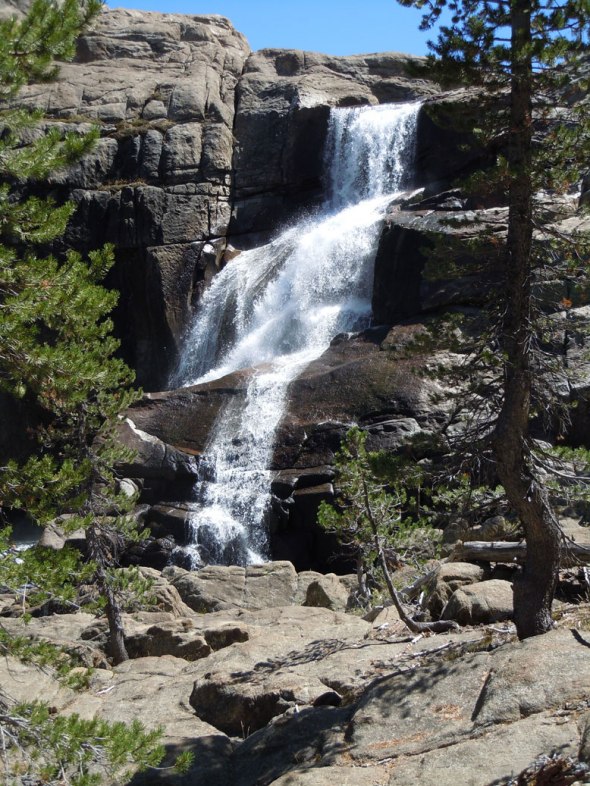
In the photo below, look carefully to the right of the patch of snow and you will see a distant waterfall. It extends quite a ways and then disappears – one cannot see it descending into the lake.

DSC_0125
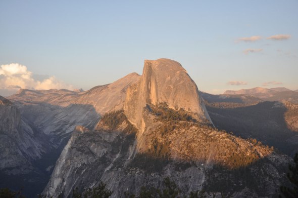
On the return, going West. DSC_0111This should be Mount Dana to the North on the return stretch. It is above 13,000 feet. Next time, a trip to Dana lake from Tioga Lake. DSC_0202
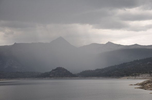
On the drive back down Tioga Road there was even more smoke and additional plumes –  there seems to have been one the way up/ just one plume of smoke. Closer to the junction of Tioga Road and 120 there were visible flames and the surrounding air at times a mysterious greenish cast and other times this golden reddish cast.  This was close to Yosemite Creek Campground. The NPS had highway 41 closed at 120 due to a new fire which had begun around 3:15 PM and is called the El Portal Fire and so could not get to 140 out so traveled out on 120, took the extension to Coulterville J20/ 132 then 49 over to Mariposa. Have done this once before – a route that is good to know. for backup plans such as this. Otherwise one needs to go over to 99, which is almost back to the Bay Area.

On this drive there were multiple fire crews traveling in and two  trucks with bulldozers.

For fire information:

http://www.nps.gov/yose/blogs/Yosemite-July-Lightning-Fire-Update-1.htm

http://wildfiretoday.com/2014/07/26/two-fires-in-yosemite-one-threatens-structures/

Summer is for Hiking: 4-Mile Trail from Glacier Point to Yosemite Valley, Yosemite National Park, September 22, 2012.

The day before my Dad’s birthday and the day of the Autumnal Equinox did the 4-Mile trail from Glacier Point. This is so one could walk down rather than up! The trail meanders downwards with switchbacks so that one is always facing the valley. My only regret is that it was so late in the season and Yosemite Falls had dried up – would like to try again when the falls are in full force. But that regret is only a minor one – the trail is filled with gorgeous vistas.

Arranged car shuttles for trip back up to Glacier Point after reaching the valley floor. Arrived back at Glacier Point just in time to capture the sunset’s light on Half Dome and a little bit later the moon over the pines.

4 Mile Trail, Yosemite National park, Sept 22, 2012. Photo by Kathryn Arnold

4 Mile Trail, Yosemite National park, Sept 22, 2012. Photo by Kathryn Arnold

Trail sign for 4-Mile Trail

Trail sign for 4-Mile Trail

Information and old-time photo of the trail (from the valley)

Information and old-time photo of the trail (from the valley)

View of Valley floor from 4-Mile trail, Sept. 22, 2012 Photo by kathryn Arnold.

View of Valley floor from 4-Mile trail, Sept. 22, 2012 Photo by kathryn Arnold.

View from 4-Mile Trail of the Valley, Sept 22, 2012. Photo by kathryn Arnold

View from 4-Mile Trail of the Valley, Sept 22, 2012. Photo by kathryn Arnold

Yosemite Falls would be here, Sept. 22, 2012. Photo by Kathryn Arnold

Yosemite Falls would be here, Sept. 22, 2012. Photo by Kathryn Arnold

Halfdome at sunset, Glacier Point. Sept 22, 2012. photo by kathryn arnold

Halfdome at sunset, Glacier Point. Sept 22, 2012. photo by kathryn arnold

Moon at Glacier Point, Sept 22, 2012. Photo by kathryn Arnold

Moon at Glacier Point, Sept 22, 2012. Photo by kathryn Arnold

Summer is for Hiking: Cathedral Lakes, Yosemite National Park, September 8, 2012 (Tuolumne Meadows area)

A week after Glen Aulin visited the Cathedral Lakes during September 2012. This trail is in the Tuolumne area of Yosemite. Lovely to have had nice-looking clouds in the sky to mirror in the water. A very beautiful effect happens as the wind travels upon the water creating rich ripples into that sky mirror (the water) and I have posted just one or two of the photos which hold that effect. Many stop at the nearest bank to have lunch/snacks but if you walk around the lake you will get a magnificent view of Tenaya Lake. The trail can go either way around the lake – the photos included here are lined up as going around the Lower Lake to the right and then wrapping along the left bank on return. Discovered a marmot who posed for multiple photos before heading along to the upper lake. The upper lake is surrounded by solid rock and interspersion of trees. A cluster of tents indicating campers were along the far side of the upper lake. A thunderstorm began while there so scurried back down to get below the tree line. I have pasted some information below describing location and altitude of the area. The hike itself has a few climbs but overall not bad at all.

“The Cathedral Lakes are two lakes located In Yosemite National Park, Mariposa County, California. The lakes are situated 1.6 km (1 mi) southwest of Cathedral Peak and 3.2 km (2 mi) east-northeast of Tenaya Lake. The lower lake is located at elevation 9,288 feet (2,831 m), while the upper lake is located at elevation 9,585 feet (2,922 m). The John Muir Trail is nearby, with a 7 miles (11 km) round trip hike of from the trailhead in Tuolumne Meadows.” http://en.wikipedia.org/wiki/Cathedral_Lakes

The trail to Cathedral Lake is part of the John Muir Trail,
http://www.yosemitehikes.com/tioga-road/cathedral-lakes/cathedral-lakes.htm

View of Cathedral Peak from lower Cathedral Lake on September 8, 2012, photo by kathryn arnold

View of Cathedral Peak from lower Cathedral Lake on September 8, 2012, photo by kathryn arnold

Trail sign to Cathedral lakes on Sept 8, 2012

Trail sign to Cathedral lakes on Sept 8, 2012

Trail sign to Cathedral lakes on Sept 8, 2012

Trail sign to Cathedral lakes on Sept 8, 2012

Lower Lake from a distance, photo by kathryn arnold

Lower Lake from a distance, photo by kathryn arnold

Approaching Lower Cathedral lake on Sept 8 2012, photo by kathryn arnold

Approaching Lower Cathedral lake on Sept 8 2012, photo by kathryn arnold

Walk around the lake to the right, photo by kathryn arnold

Walk around the lake to the right, photo by kathryn arnold

View of Tenaya Lake from Cathedral Lake on Sept 8, 2012, photo by kathryn arnold

View of Tenaya Lake from Cathedral Lake on Sept 8, 2012, photo by kathryn arnold

Walk around the lake returning along the left bank , ripples in the water. Photo by kathryn arnold

Walk around the lake returning along the left bank , ripples in the water. Photo by kathryn arnold

Marmot at Cathedral Lake on Sept 8, 2012, photo by kathryn arnold

Marmot at Cathedral Lake on Sept 8, 2012, photo by kathryn arnold

Along the way to Upper Cathedral Lake, sept 8, 2012. photo by kathryn arnold

Along the way to Upper Cathedral Lake, sept 8, 2012. photo by kathryn arnold

View of Upper Cathedral Lake, Sept 8, 2012. photo by kathryn arnold

View of Upper Cathedral Lake, Sept 8, 2012. photo by kathryn arnold

Summer is for Hiking: Glen Aulin Trail, Tuolumne Meadows, Yosemite Natl. Park, Ca. September 1, 2012

September 1, 2012 over Labor Day Weekend an impulsive but beautiful hiking choice. I should have had my hiking shoes this time as the trail has vertical cobblestones as one nears the falls. For some reason the hiking book in use had a distance of around 2 miles (a glaring typo) but by the time 2 miles was reached, definitely did not want to turn back. The hike to and from Toulomne Falls is more like 5 miles one way or more, depending on where you begin so 10-12 miles total. This hike has nearly everything you would wish for from cascades to the Tuolumne Falls and connectors to high mountain lakes (such as McGee Lake and more) and the High Sierra Camps. The trail is part of the Pacific Crest Trail and the mountains one walks alongside are 8000 plus feet high. Went to McGee Lake and High Sierra Camp Glen Aulin all in one day – a long hike! The trail is not clearly marked for the return along the huge slabs of rocks – noted many off the trail including myself. The trail runs along the boundary of the rock slabs and the forest (up) on the return.

Tuolumne River alongside Glen Aulin Trail,photo by Kathryn Arnold

Tuolumne River alongside Glen Aulin Trail photo by Kathryn Arnold

sign marking Yosemite Wilderness, photo by Kathryn Arnold

sign marking Yosemite Wilderness photo by Kathryn Arnold

This is just one of the  vistas.photo by Kathryn Arnold

This is just one of the vistas. photo by Kathryn Arnold

Sheets of Solid Rock. The day of the hike someone was running the entire trail and up and down the mountainsides of rocks  - seemed like a Greek god. photo by Kathryn Arnold

Sheets of Solid Rock. The day of the hike someone was running the entire trail and up and down the mountainsides of rocks – seemed like a Greek god. photo by Kathryn Arnold

Tuolumne River along the trail a ways further, photo by Kathryn Arnold

Tuolumne River along the trail a ways further, photo by Kathryn Arnold

Saw two sets of falls, this is Tuolumne Falls, photo by Kathryn Arnold

Saw two sets of falls, this is Tuolumne Falls, photo by Kathryn Arnold

Sign to the mountain Lakes. Went to McGee Lake. Photo by Kathryn Arnold

Sign to the mountain Lakes. Went to McGee Lake. Photo by Kathryn Arnold

McGee Lake, Glen Aulin Trail, photo by Kathryn Arnold

McGee Lake, Glen Aulin Trail, photo by Kathryn Arnold

Sign to return, photo by kathryn Arnold

Sign to return, photo by kathryn Arnold

Better view of map, photo by kathryn arnold

Better view of map, photo by kathryn arnold

On return around 8 PM, walked between a herd of deer, glen aulin trail, photo by kathryn arnold

On return around 8 PM, walked between a herd of deer, glen aulin trail, photo by kathryn arnold

Summer Is For Hiking: Florence Lake, August 18 2012

On August 18 2012 drove to Florence Lake in the Sierra Nevada near Shaver Lake area, John Muir Wilderness, California. However there was a storm coming in with large amounts of lightning. I caught part of the storm as she was coming in but did not have time to hike around the lake before the storm drew close. This will happen on another visit. Here are views of the lake and surrounding mountains. It is very scenic and quiet; the road to get there at times allows only one vehicle. It appears the lake will be drained for one year http://www.florence-lake.com/

Florence Lake Aug 18, 2012 photo by Kathryn Arnold

Florence Lake Aug 18, 2012 photo by Kathryn Arnold

Storm Coming In, Florence Lake, August 18, 2012 photo by Kathryn Arnold

Storm Coming In, Florence Lake, August 18, 2012 photo by Kathryn Arnold

Storm Coming In, Florence Lake, August 18, 2012 photo by Kathryn Arnold

Storm Coming In, Florence Lake, August 18, 2012photo by Kathryn Arnold

Traveling Storm Across Florence Lake, Sierra Nevada near Shaver

Traveling Storm Across Florence Lake, Sierra Nevada near Shaver lake, California

Summer is for Hiking: Redwood Canyon Grove, Kings Canyon National Park, 2012 july 21

 Redwood Canyon Grove, Kings Canyon National Park, 2012 july21  kathryn arnold

Redwood Canyon Grove, Kings Canyon National Park, 2012 july21 kathryn arnold

On July 21 of 2012 explored the Redwood Canyon Grove Trail. This is one of the largest groves of sequoias in existence and on this trail, one can view many of them. The trail is serene and quiet even in July. Another temperature win – in the central valley the temperature in the 100s on this particular day and here it was possibly 80 or less. The trail itself takes you through differing environments, from meadows to vistas, fern-laden areas with extremely large plants, and the wildflowers tremendous. It was hard to believe it was the dry part of summer. Green, moist and colorful surrounded by forest with the subtle mountain stream. The hike itself is not difficult and there are many segments to travel on.

 Redwood Canyon Grove, Kings Canyon National Park, 2012 july21  kathryn arnold

Redwood Canyon Grove, Kings Canyon National Park, 2012 july21 kathryn arnold

 Redwood Canyon Grove, Kings Canyon National Park, 2012 july21  kathryn arnold

Redwood Canyon Grove, Kings Canyon National Park, 2012 july21 kathryn arnold

 Redwood Canyon Grove, Kings Canyon National Park, 2012 july21  kathryn arnold

Redwood Canyon Grove, Kings Canyon National Park, 2012 july21 kathryn arnold

 Redwood Canyon Grove, the creek,  Kings Canyon National Park, 2012 july21  kathryn arnold

Redwood Canyon Grove, the creek Kings Canyon National Park, 2012 july21 kathryn arnold

 Redwood Canyon Grove, Kings Canyon National Park, 2012 july21  kathryn arnold

Redwood Canyon Grove, Kings Canyon National Park, 2012 july21 kathryn arnold

 Redwood Canyon Grove, Creek,  Kings Canyon National Park, 2012 july21  kathryn arnold

Redwood Canyon Grove, Creek, Kings Canyon National Park, 2012 july21 kathryn arnold

 Redwood Canyon Grove, Wildflowers, Kings Canyon National Park, 2012 july21  kathryn arnold

Redwood Canyon Grove, Wildflowers, Kings Canyon National Park, 2012 july21 kathryn arnold

 Redwood Canyon Grove, boulders, Kings Canyon National Park, 2012 july21  kathryn arnold

Redwood Canyon Grove, boulders, Kings Canyon National Park, 2012 july21 kathryn arnold

 Redwood Canyon Grove, View, Kings Canyon National Park, 2012 july21  kathryn arnold

Redwood Canyon Grove, View, Kings Canyon National Park, 2012 july21 kathryn arnold

 Redwood Canyon Grove, Meadow, Kings Canyon National Park, 2012 july21  kathryn arnold

Redwood Canyon Grove, Meadow, Kings Canyon National Park, 2012 july21 kathryn arnold

 Redwood Canyon Grove, Ferns and Flowers, Kings Canyon National Park, 2012 july21  kathryn arnold

Redwood Canyon Grove, Ferns and Flowers, Kings Canyon National Park, 2012 july21 kathryn arnold

 Redwood Canyon Grove, fallen tree, Kings Canyon National Park, 2012 july21  kathryn arnold

Redwood Canyon Grove, fallen tree, Kings Canyon National Park, 2012 july21 kathryn arnold

 Redwood Canyon Grove, flowers, Kings Canyon National Park, 2012 july21  kathryn arnold

Redwood Canyon Grove, flowers, Kings Canyon National Park, 2012 july21 kathryn arnold

 Redwood Canyon Grove, trees, Kings Canyon National Park, 2012 july21  kathryn arnold

Redwood Canyon Grove, trees, Kings Canyon National Park, 2012 july21 kathryn arnold

 Redwood Canyon Grove, Giant Tree, Kings Canyon National Park, 2012 july21  kathryn arnold

Redwood Canyon Grove, Giant Tree, Kings Canyon National Park, 2012 july21 kathryn arnold

Summer is for Hiking: Weaver Lake, near border of King’s Canyon National Park, Ca. July 5, 2012

This is a great day hike, the trail well-marked and the lake has multiple spaces for overnight camping. It was amazing the temperature change at the height of Weaver Lake – the air was crispy cool on a day that it was over 100 in the valley. One could also do an overnight loop and include Jennie Lakes as well (my next time project) . Weaver Lake is a secluded quiet alpine lake at the base of Shell Mountain. (a website which gives the overnight loop info and directions to arrive at the trailhead: http://www.everytrail.com/guide/jennie-and-weaver-lakes-loop/)

Trailmarker to Weaver's Lake, King's Canyon National Park, California

Trail marker to Weaver’s Lake, King’s Canyon National Park, California, Kathryn Arnold, July 5th, 2012

The trail is a bit difficult to see from the parking area but it is lined with rocks.

Wildflowers on way to Weaver's Lake, King's Canyon National Park, California. Kathryn Arnold. July 5, 2012.

Wildflowers on way to Weaver’s Lake, King’s Canyon National Park, California. Kathryn Arnold. July 5, 2012.

Everything is still very green and many wildflowers at the beginning of July.

Water on way to Weaver's Lake, King's Canyon National Park, California. Kathryn Arnold. July 5, 2012.

Water on way to Weaver’s Lake, King’s Canyon National Park, California. Kathryn Arnold. July 5, 2012.

View on way to Weaver's Lake, King's Canyon National Park, California. Kathryn Arnold. July 5, 2012.

View on way to Weaver’s Lake, King’s Canyon National Park, California. Kathryn Arnold. July 5, 2012.

Wildflowers on way to Weaver's Lake, King's Canyon National Park, California. Kathryn Arnold. July 5, 2012.

Wildflowers on way to Weaver’s Lake, King’s Canyon National Park, California. Kathryn Arnold. July 5, 2012.

View on way to Weaver's Lake, King's Canyon National Park, California. Kathryn Arnold. July 5, 2012.

View on way to Weaver’s Lake, King’s Canyon National Park, California. Kathryn Arnold. July 5, 2012.

Forest on way to Weaver's Lake, King's Canyon National Park, California. Kathryn Arnold. July 5, 2012.

Forest on way to Weaver’s Lake, King’s Canyon National Park, California. Kathryn Arnold. July 5, 2012.

 Greeting to Jennie Lakes Wilderness on way to Weaver's Lake, King's Canyon National Park, California. Kathryn Arnold. July 5, 2012.

Greeting to Jennie Lakes Wilderness Kathryn Arnold. July 5, 2012.

Weaver Lake Sign on way to Weaver Lake, King's Canyon National Park, Kathryn Arnold, July 5, 2012

Weaver Lake Sign on way to Weaver Lake, King’s Canyon National Park, Kathryn Arnold, July 5, 2012

Weaver Lake, King's Canyon National Park, Kathryn Arnold, July 5, 2012

Weaver Lake, King’s Canyon National Park, Kathryn Arnold, July 5, 2012

Weaver Lake, King's Canyon National Park, Kathryn Arnold, July 5, 2012

Weaver Lake, King’s Canyon National Park, Kathryn Arnold, July 5, 2012

Weaver Lake, King's Canyon National Park, Kathryn Arnold, July 5, 2012

Weaver Lake, King’s Canyon National Park, Kathryn Arnold, July 5, 2012

Weaver Lake, King's Canyon National Park, Kathryn Arnold, July 5, 2012

Weaver Lake, King’s Canyon National Park, Kathryn Arnold, July 5, 2012

Weaver Lake, King's Canyon National Park, Kathryn Arnold, July 5, 2012

Weaver Lake, King’s Canyon National Park, Kathryn Arnold, July 5, 2012

Simply lovely.

Trailmarker, Weaver Lake, King's Canyon National Park, Kathryn Arnold, July 5, 2012

Trailmarker, Weaver Lake, King’s Canyon National Park, Kathryn Arnold, July 5, 2012

Butterflies on return from Weaver Lake, King's Canyon National Park, Kathryn Arnold, July 5, 2012

Butterflies on return from Weaver Lake, King’s Canyon National Park, Kathryn Arnold, July 5, 2012

Butterflies hovering and grouping near watery areas – must have been at least 100.

Summer is for Hiking: Nelder Grove sequoias, Sequoia National Forest, June 23 2012

With summer over, I am finding the time to update on the various hikes from the season. A lot of time was spent in the mountains of Yosemite and Kings Canyon. This hike pictured here was into Nelder Grove, an area with original sequoias near Yosemite and near Ansel Adams Wilderness. We took the hike towards the Granddad tree and in June, there were many wildflowers. It is not a difficult hike – at the end one can go further on an adjoining trail but there are no designated markers.

Nelder Grove sequoia, Sequoia National Forest, June 23 2012,  Kathryn Arnold

sequoia 1, Nelder Grove sequoia, Sequoia National Forest, June 23 2012, Kathryn Arnold

Nelder Grove sequoia, Sequoia National Forest, June 23 2012,  Kathryn Arnold

Sign, Nelder Grove sequoia, Sequoia National Forest, June 23 2012, Kathryn Arnold

Map, Nelder Grove sequoia, Sequoia National Forest, June 23 2012,  Kathryn Arnold

Map Nelder Grove sequoia, Sequoia National Forest, June 23 2012, Kathryn Arnold

original log cabin, Nelder Grove sequoia, Sequoia National Forest, June 23 2012,  Kathryn Arnold

Original Log Cabin, Nelder Grove sequoia, Sequoia National Forest, June 23 2012, Kathryn Arnold

Nelder Grove sequoia, Sequoia National Forest, June 23 2012,  Kathryn Arnold

Nelder Grove sequoia, Sequoia National Forest, June 23 2012, Kathryn Arnold

Nelder Grove sequoia, Sequoia National Forest, June 23 2012,  Kathryn Arnold

Nelder Grove sequoia, Sequoia National Forest, June 23 2012, Kathryn Arnold

Nelder Grove sequoia, Sequoia National Forest, June 23 2012,  Kathryn Arnold

Nelder Grove sequoia, Sequoia National Forest, June 23 2012, Kathryn Arnold

Nelder Grove sequoia, Sequoia National Forest, June 23 2012,  Kathryn Arnold

Nelder Grove sequoia, Sequoia National Forest, June 23 2012, Kathryn Arnold

Nelder Grove sequoia, Sequoia National Forest, June 23 2012,  Kathryn Arnold

Nelder Grove sequoia, Sequoia National Forest, June 23 2012, Kathryn Arnold

Nelder Grove sequoia, Sequoia National Forest, June 23 2012,  Kathryn Arnold

Nelder Grove sequoia, Sequoia National Forest, June 23 2012, Kathryn Arnold

Nelder Grove sequoia sign, Sequoia National Forest, June 23 2012,  Kathryn Arnold

Nelder Grove sequoia sign, Sequoia National Forest, June 23 2012, Kathryn Arnold

Nelder Grove sequoia sign, Sequoia National Forest, June 23 2012,  Kathryn Arnold

Nelder Grove sequoia sign, Sequoia National Forest, June 23 2012, Kathryn Arnold

Nelder Grove sequoia, Sequoia National Forest, June 23 2012,  Kathryn Arnold

Nelder Grove sequoia, Sequoia National Forest, June 23 2012, Kathryn Arnold

Nelder Grove sequoia, Sequoia National Forest, June 23 2012,  Kathryn Arnold

Nelder Grove sequoia, Sequoia National Forest, June 23 2012, Kathryn Arnold

Nelder Grove sequoia, Sequoia National Forest, June 23 2012,  Kathryn Arnold

Nelder Grove sequoia, Sequoia National Forest, June 23 2012, Kathryn Arnold

Nelder Grove sequoia, Sequoia National Forest, June 23 2012,  Kathryn Arnold

Nelder Grove sequoia, Sequoia National Forest, June 23 2012, Kathryn Arnold

Spring into Water Trough, Nelder Grove sequoia, Sequoia National Forest, June 23 2012,  Kathryn Arnold

Spring into Water Trough, Nelder Grove sequoia, Sequoia National Forest, June 23 2012, Kathryn Arnold

Vegetation, Nelder Grove sequoia, Sequoia National Forest, June 23 2012,  Kathryn Arnold

Vegetation, Nelder Grove sequoia, Sequoia National Forest, June 23 2012, Kathryn Arnold

Flowers at Nelder Grove, Sequoia National Forest, June 23 2012,  Kathryn Arnold

Flowers at Nelder Grove, Sequoia National Forest, June 23 2012, Kathryn Arnold

Flowers at Nelder Grove, Sequoia National Forest, June 23 2012,  Kathryn Arnold

Flowers at Nelder Grove, Sequoia National Forest, June 23 2012, Kathryn Arnold

Flowers at Nelder Grove, Sequoia National Forest, June 23 2012,  Kathryn Arnold

Flowers at Nelder Grove, Sequoia National Forest, June 23 2012, Kathryn Arnold

Flowers at Nelder Grove, Sequoia National Forest, June 23 2012,  Kathryn Arnold

Flowers at Nelder Grove, Sequoia National Forest, June 23 2012, Kathryn Arnold

Flowers at Nelder Grove, Sequoia National Forest, June 23 2012,  Kathryn Arnold

Flowers at Nelder Grove, Sequoia National Forest, June 23 2012, Kathryn Arnold

Flowers at Nelder Grove, Sequoia National Forest, June 23 2012,  Kathryn Arnold

Flowers at Nelder Grove, Sequoia National Forest, June 23 2012, Kathryn Arnold

Flowers at Nelder Grove, Sequoia National Forest, June 23 2012,  Kathryn Arnold

Flowers at Nelder Grove, Sequoia National Forest, June 23 2012, Kathryn Arnold

Summer Is For Hiking: Tanbark Trail, Big Sur area, Ventana Wilderness on June 16, 2012

Mounds of Clover

Mounds of Clover, lower section of Tanbark Trail, Big Sur Area/ Ventana Wilderness on June 16 2012, kathryn arnold

Summer Is For Hiking

On June 16 2012, after stopping at the ranger’s station near Big Sur to inquire which trails were closed and after discovering Edwoldsen was still closed, and since Tanbark trail was recommended we got a late start (11:30 AM) up the trail.

The trailhead is on the land side of highway 1 across from Partington Cove. http://www.hikinginbigsur.com/hikemap.html

We first encountered a choice – to either hike on the right side of the creek or the left side. We selected the right side first but after scrambling through 2 rock slides and heavy brush determined to try out the left side of the creek.

Don't go this way (south side of creek)

Don’t go this way (south side of creek)

Below is an image of one of the rock slides.

Rockslide on south side of Partington Creek

Rockslide on south side of Partington Creek, blocks the trail

Instead select the trail to the left side of the creek.

The way to go

The way to go – Tanbark trail

This comes along with a clear sign designating the way.

Tanbark Trail Sign

Tanbark Trail Sign

Beautiful redwoods, clover, ferns dot the path along the creek transcending the hillsides. Little did we know that it would not remain as cool at the top as it was at the base – had we known we would have begun much earlier in the day with more water.

Hillside at Beginning of trail

Hillside at beginning of trail

Above and below are sample images of the surrounding landscape.

Creek and Clover

Partington Creek with clover mounds at beginning of Tanbark trail

Looking up there is indication of the 3.2 climb of 1400 feet which is attained through a variety of switchbacks through redwood forests and then later groves of what must be Tanbark Oaks. From what I have read, the tanbark oak is more like an evergreen beech tree.

Steep Hillside

Steep Hillside on Tanbark trail

The trail meanders upward through alternating full sun and shaded areas.

Along the way

Along the way on Tanbark Trail

There are wildflowers at everyturn as we hit the full sun sections of the trail which are filled with nonaggressive bees. Many times the flowers spread into the trail. The variety of flowers is quite extensive.

Flowers in open sun

Flowers in open sun, Tanbark trail

Columbines also fill the hillsides. Here is one that was close to the trail.

columbine growing everywhere

columbine growing everywhere

Continuing upwards for awhile now. The trail back down will also be somewhat steep.

Headed up

Headed up, June 16 2012, Tanbark trail

Along the upward journey, views of the ocean begin to appear.

climbing - with view of ocean

climbing – with view of ocean to remind of ‘why’

With each view we felt we must be almost there…but not!

view of pacific on the way up

view of pacific on the way up

Below is a photo of what may be the Tanbark oaks. The bark has peeled off many of them.

Tanbark Oaks

Possibly Tanbark Oaks, kathryn arnold

At the top the view is outstanding – one can see forever, it seems.

View from the top, south

how to see forever, view towards south, pacific coastline from top of Tanbark Trail, kathryn arnold

We may have missed the actual Tin House. Some fellow hikers were up there as well and they also did not know where it was. We did locate a large pile of rusted tin on the ground and assumed this was it. Since returning – I looked online and see actual images of a house.

View from the top, north view of coastline

View from the top, north view of coastline, kathryn arnold

The coastline is breathtaking.

Coastline, Pacific Ocean

Coastline (to the South) , Pacific Ocean from top of Tanbark Trail

The ranger had spoken to us about this Connector trail – it leads to an overlook of Edwoldsen Canyon and then if you wish, you could hike down. He warned of downed trees.

View from Connector Trail

View from Connector Trail, June 16, 2012, kathryn arnold

So this image displays a grand view of the Connector trail. There is a sign that directs you to traverse to the left to journey on.

Connector Trail to Edwoldsen Overlook

Connector Trail to Edwoldsen Overlook by kathryn arnold

Up at the top one has multiple decisions to make. One can head down using the road and then walk a mile back to the Partington turnout. We opted not as walking on Highway 1 felt precarious and journeyed back down the way we came up.

Heading back down with view of creek

Heading back down with view of creek by kathryn arnold

The sun had shifted and we arrived at the base by 5 PM.

Redwoods and Clover

Redwoods and Clover, June 16 2012, Tanbark Trail by kathryn arnold

The lighting took on a mesmerizing quality and as we entered the redwoods once again, it is as if someone had turned on the AC.

mound of clover, tanbark trail

mound of clover, tanbark trail, june 16, 2012, kathryn arnold

These are some photographs taken in the late afternoon.

Trip back down Tanbark Trail

Trip back down Tanbark Trail, natural AC by kathryn arnold

And here are some more.

Forest Floor

Forest Floor by Kathryn Arnold

And here is another.

Redwoods on Forest Floor

Redwoods on Forest Floor, Tanbark trail

Hiking King’s Canyon to the Boole tree, September 17, 2011

New meaning for Massive: the Boole Tree

New meaning for Massive: the Boole Tree, photo by kathryn arnold

Last weekend traveled over to King’s Canyon to finally see the Boole tree. I had been wanting to do this for awhile, especially after seeing jerry uelsmann’s photography relating to this sequoia- considered to be the largest in volume. At least I think I remember him using this tree and discussing it but cannot find this information online currently.

The trail is well-maintained traveling upward for awhile…we went to the left so encountered the panoramic views early on. Then the Boole tree emerges like an unexpected mythic giant.

Panoramic View from the Boole Trail, King's Canyon National Park

Panoramic View from the Boole Trail, King's Canyon National Park, photo by kathryn arnold

View with sunspots on way to Boole Tree

View with sunspots on way to Boole Tree, photo by kathryn arnold

Emergence of the Boole Tree, King's Canyon National Park

Emergence of the Boole Tree, King's Canyon National Park, photo by kathryn arnold

Me at the Boole tree

Me at the Boole tree

Boole Tree, King's Canyon National Park

Boole Tree, King's Canyon National Park, photo by kathryn arnold

Graceful Giant Monarch - Boole Tree

Graceful Giant Monarch - Boole Tree, photo by kathryn arnold